The Photo Vault: Millewa Pioneer Village


Millewa Pioneer Village

Millewa Pioneer Village, Victoria, Australia, 2006

A journalist friend of mine had a story to file about an open day at the Millewa Pioneer Park in Meringur, a tiny town about an hour or so from Mildura, so she invited me along for the day. I was very involved in my community, and this is just one of the types of things that would fill up my weekends.

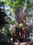
The Millewa Pioneer Village is a site where a collection of buildings and vintage farm implements, show what life as a farming pioneer in the olden days was like. There is a good collection of history and displays that while interesting, also show the decline in population that is is an important issue in rural Australia.

The population drain on rural and regional Australia isn´t just the young people being drawn to the bright lights of the cities for study and work, but is also a result of changing farm practices, technological advances in agriculture and economics. In order to make a living, farms are bigger than they were when the settlers arrived to farm their parcel of land. Over the years farms have been consolidated, and what was once a viable farm for a family and their grown children also working the farm, no longer provides a living for just one family. So as a result of the growing farm sizes to support a family, the population in these rural areas has declined to reflect this change.

It´s a difficult issue because services that were once available, also become unviable. But one of the beautiful things about rural communities is their spirit and their tenacity. The open day was a success and many people came out to support the day, not just locals, but people from Mildura and other small towns.

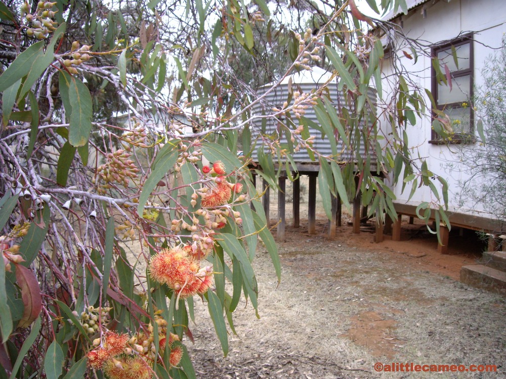
I miss my community. I miss being involved in activities and events that make my hometown a better place. I miss the friendships and acquaintances I have there and I miss bumping into people I know and having a little chat truly caring about what they are up to. I haven´t yet found a way of carving out my own community here in Santa Marta, and perhaps that is another factor making me feel rootless at the moment. But this photo, of the mallee scrub, with a gorgeous flowering gum and the iconic corrugated iron water tank makes me feel that my community will always be there, waiting for me to return.

The Photo Vault is where I will be sharing my favourite photos (and their stories) that deserve better than being lost in the depths of my iPhoto never to be shared.

Marinka Waterfalls – Minca

It’s amazing what you’ll find if you follow some random road.

Mi novio is in love with our motorbike and so when we had a Sunday with no plans, he suggested a trip to the beach. Being smack bang in the middle of high season with the beaches jammed with visitors and locals making a paseo, I suggested we head for the hills instead. So we set off in the direction of Minca.

On the ride uphill we passed a number of balnearios, or swimming holes in the river that are much like your local swimming pool. Some have been fortified with concrete and have restaurants and bars. All have loud vallenato music blaring and so it’s best to press on to find nature at its best.

Minca is a lovely and tiny town in the Sierra Nevada de Santa Marta and sits at about 600m above sea level. The climate is fresh and the area abounds with coffee farms, forest and bird watching. If you’re looking for a place to chill out, Minca certainly offers that.

After crossing the bridge over the Minca River, we took the road to right and rode past the church and a few small market stalls set up under the trees. At the end of the strip of buildings, the road continued and was paved – or rather the two tyre ruts were paved. I asked mi novio what was up ahead and he didn’t know, so we decided to find out. We followed a 4WD ute with a bunch of Colombians in the back for a while and as the road got steep, bumpy (and unpaved) and too much for our little scooter with 2 passengers, we passed a group of people on foot. Clearly there was something worth seeing up ahead, but what, we had no idea so we asked. It turned out there were waterfalls.

I am a sucker for waterfalls. I really love them. Mi novio had no choice but to continue and I had no choice but to get off and walk a few of the steeper sections of road to avoid overheating our poor motorbike. After a good 20 minutes on the motorbike we came to the turn off to Marinka Waterfalls. A vendor was selling snacks on the roadside and as we stopped for a coca-cola I got bitten by tiny little mosquitoes which made me wish I had brought repellent as well as sunscreen. The mosquitoes only seemed to be at that one spot, and as we parked the bike and walked the last 400m to the waterfalls thankfully they disappeared.

As with most natural attractions in Colombia, you couldn’t just discover the waterfall in its natural setting. A couple of roofed huts have been added, with one serving a rustic set-menu lunch. I was pleased to be charged the Colombian entrance fee rather than that for foreigners. If I just keep my mouth shut and let mi novio do all the talking, I can often get away with this.

The waterfalls have two drops, a cascade of about 20m and a drop of about 10m, into pools that you can swim and relax in.

We didn’t really spend much time there, but had a bit of a swim and relaxed while marvelling over our random discovery because even mi novio didn’t know about this waterfall.

As we were leaving the site we came across four almost elderly people who we’d seen struggling at the turn off. They had walked all the way from Minca to the waterfalls and then refused to pay the entrance fee and so were turning back around. They argued that you shouldn’t have to pay to see nature and the guy collecting the entrance fee said that the site needed to be maintained. Whilst I agree with their sentiments,  I know it is common to have to pay. During my roadtrip in the US, I visited a lot of national parks and each had an entry fee (although buying an annual pass is much more cost-effective if you plan to visit a few US National Parks). However at the end of the day, I think if I’d spent an hour or more walking uphill in the heat, I would pay the small entrance fee to cool off rather than turn around in stubborn defeat.

This slideshow requires JavaScript.

~~~~~~~~~~~~~~~~~~~~~~~~~~~~~~~~~~~~~~~~~~~~~~~~~~~~~~~~~~~~~~~~~~~~~~~~~~~~~~~~~~~~~~~~~~~~~~~~~~~~~~~~~~~~

Want to go to Marinka Waterfalls?

What’s there: Waterfalls, swimming and a walk in the Sierra Nevada de Santa Marta

How to get there: Take a collectivo to Minca that leaves from Calle 11 and Carrera 12 near the Mercado in Santa Marta between 8am and 5:30pm (COP$6000, US$3.40), a mototaxi or taxi (COP$40,000, US$22.60 from Santa Marta). Cross the bridge over the Minca River and take the road forking to your right past the church. Continue following this road uphill for about an hour. Just after you ford the river, you will see a stall and signs to Marinka Waterfalls on your left. If the walk is too much, you can also hire a mototaxi from Minca to take you there.

Entry fee: COP$2000 per person (US$1.10) for Colombians or COP$3000 per person (US$1.70) for foreigners

Hike difficulty: Moderate. The path doubles as a road but the walk to the waterfalls is uphill.

Walk time: Approximately 1 hour from the church to the waterfalls.

What to take: Sandals or walking shoes, water, sunscreen, snacks, money, bathing suit, towel and camera.

Roadtrip to Quebrada Valencia

We finally stretched the legs of our new motorbike with a day trip to the cascades at Quebrada Valencia.

With $3 worth of petrol in the tank, we headed east along the Troncal Caribe in the direction of Riohacha. I am not the best pillion passenger as I have a tendency to dig my nails in and yell into the ear of mi novio should we approach other vehicles too quickly, go over speed humps (or dead policemen as they call them here) without braking, overtake trucks or buses and I curse and scream “I don’t like this” when we weave in and out of traffic. But, after leaving Santa Marta’s city limits, we were suddenly quite alone on a well paved highway and riding under a canopy of green forest.

The air was cooler and the scenery divine. The wind blew all of the weariness and frustrations of the city away. Instead of screaming in mi novio’s ear to slow down or pay more attention, I was conversing with him, constantly exclaiming “This is so lovely.”

While I marvelled over the scenery and breathed in the fresh air (any odd insect or two), I realised that it must be quite tedious listening to me rabbit on about the scenery when he has passed by this same route thousands of times for his work but he told me that it was a completely different sensation on the motorbike where you really feel your surroundings to that of watching out the bus window.

50km and a bit over an hour later, we arrived at Quebrada Valencia, with an internationally recognised tourist attraction brown sign announcing the destination. The entrance to Quebrada Valencia is right beside the highway with a small pull-in on either side, a local store and a market stall selling aqua socks to the Colombians from the interior who can’t bear crossing the river in their sandals or bare feet.

Quebrada Valencia, with its impressive range of cascading falls, is a 20 – 30 minute walk from the entrance and our first task was to cross the river. During dry season, the river is clear, shallow and tranquil, making the crossing (and subsequent crossings) quite easy. On the other side we passed by vendors selling coffee and fresh cooked arepas and walked alongside a banana plantation for a little bit. Not far into our walk we came across an enormous tree blocking the path, forcing everyone to walk around it. The tree has great clumps of root-like vines dangling down, and looks rather like you would imagine a tree relative of Mr Snuffleupagus from Sesame Street.

We continued our easy walk in the forest and crossed the river another five times to reach the lower swimming pools and rocky cascades of Quebrada Valencia.

It’s a popular spot for tourists and locals who take along picnics, and even their own hammocks. The falls drop over a rocky vein that obstructs the river’s flow and creates pools at different levels and some great jumping points.

We were instantly enamoured, and climbed the rocks to find a little ledge under a shady branch to leave our belongings while taking a refreshing dip in the rock pools and a slide down rocks beaten smooth by the water current. It is a great spot to relax and unwind and enjoy the company of family and friends. I couldn’t believe when mi novio said he hadn’t been there before. Not even on a family outing with his parents or with other friends.

Further up were more water pools and great views of each waterfall and all the way down to the end of the cascades, but we couldn’t climb up to the very top as it was cordoned off with plastic ‘do not enter’ tape and had a guy posted beside to enforce the no climbing rule.

After an afternoon of bathing in the lovely rock pools, we followed the easy trail back to the entrance and our motorbike, all the while exclaiming that we will have to bring D and la suegra here one day. Quebrada Valencia really is an all-round great day trip for lovers, families and groups of friends.

~~~~~~~~~~~~~~~~~~~~~~~~~~~~~~~~~~~~~~~~~~~~~~~~~~~~~~~~~~~~~~~~~~~~~~~~~~~~~~~~~~~~~~~~~~~~~~~~~~~~~~~~~~~~

Want to go to Quebrada Valencia?

What’s there: Waterfalls, swimming and a short hike in the Sierra Nevada de Santa Marta

How to get there: Take the Troncal Caribe from Santa Marta towards Riohacha by car or motorbike (parking COP$2000 – $3000 at the entrance) or by a public bus that leaves from Calle 11 near the Mercado in Santa Marta that also passes by Parque Tayrona (ask to be dropped at Quebrada Valencia) and then flag down any return bus.

Entry fee: COP$3000 per person (US$1.65)

Hike difficulty: Easy but must be able to cross the rivers, the walking path is flat and well looked after

Walk time: 20 – 30 minutes

What to take: Sandals or flip flops, water, sunscreen, snacks or money to buy from vendors along the way, towel and camera.

Dust storm

The dust storm coming in from the west

The magnificent force of nature where I grew up is best demonstrated by a dust storm.

A tsunami of red sand billowing towards you from the west, gathering dust particles from wheat and sheep paddocks, blocking out the sun and giving a rosy haze to the sky is quite spectacular. From the vantage point of the family home, perched atop a red sand dune is truly quite awe-inspiring.

A few years ago a major dust storm crossed Australia from west to east and arrived in Sydney carrying the legacy of our deserts. This caused widespread amazement and many photos of the Sydney Harbour Bridge and Sydney Opera House bathed in a red hue. But where I’m from, this isn’t so unusual. Granted, it’s not an everyday occurrence, but you get a handful of big dust storms each year that make you hurry home to close the windows.

The dust storm dominating the sky

I was with my parents in the truck on Good Friday and as we travelled back home, we drove into the dust storm. The sky darkened and the windswept red rivulets of sand across the highway. As we turned off the highway we started to come out the other side od the dust storm. The mirrors were filled with a stormy red sky and in front of us lay a wide expanse of blue with some wispy white clouds.

“We’d best get home quick to close the windows,” my parents said.

Arriving at home we ran to make sure all the windows were closed and take the clothes off the line and then we were enveloped in the storm.

Water tank in the dust storm
A water tank stands sentinel during the dust storm

There is something so ethereal about the light and a quiet eerieness to a dust storm, there is a palpable sentiment to the westerly winds carrying the desert. I wandered around the house, searching for the best lookout point and occasionally coughing at the gritty sand that was drying out my mouth.

As I’m about to move to a hilly green seaside town in Colombia, I really appreciated the red sand show nature put on for me.

The Appalachian Trail

Stretching for 2000 miles from Maine to Georgia is the famous Appalachian Trail. For many hikers, this is the ultimate adventure, and if they can’t complete the whole thing at once (a huge commitment) then they will cover it piece by piece.

Atop the Smoky Mountains at the state border between Tennessee and North Carolina, there is a monument and a 1.7 mile section of the Appalachian Trail you can complete.

On this trip I’ve discovered a bit of a liking for hiking. In Peru all those years ago I discovered I didn’t like walking up or downhill. Something rather limiting when travelling in mountainous regions. But I think that laziness has faded, and I don’t mind exerting some effort to climb a mountain or descend a canyon.

Therefore, I wasn’t going to pass up the ability to say I’d hiked part of the Appalachian Trail. I set out from a carpark full of Americans and expected to find the trail heavily trafficked. Well, as my Lonely Planet explains, 90% of visitors don’t venture further than 100 yards from their car. I found this to be true. The first stretch was filled with families, but after a couple of hundred metres, the trail was quiet and just had a few people passing by.

Maybe here it was that I started to flesh out the idea that Americans aren’t particularly adventurous. I hasten to add that I have also met many adventurous Americans in my travels,  it just seems people are less likely to take risks and will continue in the well-worn formula of life – school, university, work, get married, raise a family, retire.

Into the mountains

It must be something to do with coming from a flat, barren topography that makes the mountains so majestic and beautiful in my mind. They are awe-inspiring and I gape with wonder.

As I neared the Great Smoky Mountains, I nearly exploded with wonder at their dense, green blanket and low wispy clouds. The steamy, jungly smell of the forest and the vivid green appealed so strongly to me.

That combination of green and mountain is completely fascinating to someone who lives on the edge of the desert and where there is only one place in town to practise handbrake starts.

I can tell I’m going to love this part of America.

Not so remote

Two planes side by side

Apparently southern Utah was the last place of the contiguous US states to be mapped due to its remoteness. However it doesn’t feel so remote when you always see a jetstream streak across the sky.

I had expected to find wide blue skies contrasting against the red rocks of the region, but many a photo will be marred by these aeroplane scars across the sky. I counted up to 10 at one time in Bryce Canyon. It makes it hard to believe you are in the middle of nowhere when you can see a criss-cross of jetstreams and it’s a continuous reminder of life going on back in the ‘real world’ and makes it difficult to truly escape.

Count the jetstreams above Bryce Canyon

Even in the quiet of the night, you still hear jets flying over in the wee hours of the morning.

It kind of spoils the nature experience.I miss the open expanse of blue sky in Australia. The type where it is rare to see a jetstream, where the jetstream is a novelty, not the norm.

CockRock State Park

Okay, so it’s really called Kodachrome Basin State Park, so named by a bunch of National Geographic boffins who thought it so captivatingly photogenic in 1949, but whatevs, it really is just a state park full of phallic rocks.

The Panorama Trail gives you plenty of opportunity to see these giant, erect formations that some giantess would probably get her rocks off on. Yes, this post is extremely vulgar, but if you want a giggle, check out the slideshow (although not the type filmed on Kodachrome, printed at the photo shop and shown with a white pull up screen and home slide projector, even though that’s probably how the Nat Geo guys showed the park off in the first place).

This slideshow requires JavaScript.

Thank you blue sky

Capitol Reef NP
Views from the end of the trail

At the Capitol Reef National Park Visitor Centre, I wasn’t so sure about the 9 mile (14.5km) Navajo Knobs trail that hiking buddy Brian was so keen on.

For starters, the weather was grey and rain looked imminent. I didn’t quite have the heart to tell him then that if it was raining, there was no way I was climbing the slickrock and no way I’d do it for 9 miles. I was fully prepared to pike out like I did on the sunset.

The threatened rain appeared as I was pitching my tent in the beautiful Fruita campground. My enthusiasm waned substantially. I suggested we go on the scenic drive “in the meantime”, and so we got in Esmeralda and travelled along the not overly scenic road. At the end of the bitumen, I decided to turn around because the last thing I would want is to get Esmeralda bogged in the sticky red dirt.

As we headed back to the campground, lo and behold, the grey skies parted and showed their blue cousin.

So I found myself ascending 2400 feet (730m) over the undulating trail. However, the views were totally worth the climb and my inner petulant child that creeped out a few times during the hike. Thanks Brian for suggesting it and thanks blue skies for making me keep my word!

A moment of solitude

Resting at Canyonlands NP
Soaking up the sunshine and solitude

It seems that all the National Parks here are teeming with visitors. All the trails are well-worn, cars spill out of carparks and it’s hard to get away from the crowds.

That’s why I was so happy to go to Canyonlands National Park just outside Moab, Utah and find fewer people. On one particular walk to Upheaval Dome, I took the longer trail to the second viewpoint and seemed to be the only person doing so. I pulled up a comfortable rock and laid down and watched the clouds push and pull across the blue sky and jets flit from east to west.

I couldn’t hear or see any other people. No crunching footsteps. No conversations. Just the quiet. And it was wonderful, a half hour of recharging in the warm sunshine with incredible views.